
Every year, we celebrate World Environment Day on June 5 and World Oceans Day on June 8.
To mark the United Nations Ocean Conference taking place in Nice from June 9-13, we wanted to highlight just how important space technologies—and Earth-observation systems in particular—are for monitoring the environment, oceans and climate phenomena affecting our one and only Blue Planet.
Observing Earth from the vantage point of space

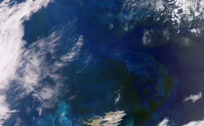
View of the Falkland Islands with Sentinel-3 © ESA
The findings of the sixth IPCC report make stark reading: global warming is accelerating, extreme weather events are on the rise, and a joint global effort is more than ever needed to mitigate the impacts. According to the report, concentrations of carbon dioxide (CO2) have reached their highest level in two million years. Over the last 100 years, sea level has risen at a rate unseen for 3,000 years.
Space technologies give us the tools to monitor our planet closely and continuously. Satellites are playing a key role in this respect, delivering invaluable data to help us understand and anticipate environmental issues. This data alone represents 60% of the essential climate variables (ECVs) on which climate change panels base their findings. Satellites continuously survey ecosystem changes and the impact of human activities, providing the broad picture needed to protect future generations.
Delving deeper into the world’s oceans
Oceans cover approximately 71% of Earth’s surface and are vital for regulating the climate and supporting global biodiversity. However, they are also among the most vulnerable to the impacts of climate change, facing challenges such as rising sea levels, changing ocean currents, acidification, and an increase in extreme weather events.
Thales Alenia Space plays a pivotal role in advancing oceanographic research, contributing to the understanding and preservation of marine environments through its globally recognized expertise in satellite altimetry.
Since the 1990s, Thales Alenia Space has become the key industry partner within a longstanding alliance between CNES and NASA, notably on the TOPEX/Poseidon mission and subsequently the Jason series of satellites, culminating in SWOT (Surface Water & Ocean Topography), a mission deploying leading-edge oceanography and surface water height technologies. Building on this heritage, Thales Alenia Space is today a world leader in satellite altimetry.
This advanced technology allows us to acquire precise ocean surface height measurements that are vital to science and environmental decision-making.
SWOT, setting the new standard for oceanography

SWOT © Thales Alenia Space/ ImagIN
Launched in December 2022, SWOT is a French-U.S. satellite that is revolutionizing oceanography and continental hydrology. A joint effort of CNES and NASA, with contributions from the Canadian Space Agency (CSA) and the United Kingdom Space Agency (UKSA), it delivers an unprecedented picture of the world’s oceans, lakes, rivers and reservoirs, mapping 90% of the planet’s surface waters.
Thales Alenia Space was lead contractor for the satellite’s development. SWOT’s main innovation is its KaRIn wide-swath radar interferometer instrument, a leap-ahead technology designed by NASA’s Jet Propulsion Laboratory (JPL). It is also carrying a Nadir module drawing on the heritage of the Poseidon altimeter built in Toulouse for the Jason missions.
SWOT features a controlled reentry subsystem to avert debris at the end of its life.
Copernicus: the world’s most complete environmental monitoring program

Copernicus © Thales Alenia Space
Copernicus is the most ambitious environmental monitoring program in the world, consisting of 12 families of satellites surveying Earth, its topography, seas, lakes, oceans, and polar regions. It also encompasses climatology missions measuring human-induced CO2 emissions and fostering new applications for sustainable agriculture and biodiversity. A program of this scale is vitally important to Europe, allowing it to better anticipate the consequences of global warming so that we can safeguard our planet.
Copernicus is thus helping European decision-makers to mitigate the impact of global warming and protect the planet.
Sentinel-1 watching over Earth, even through clouds
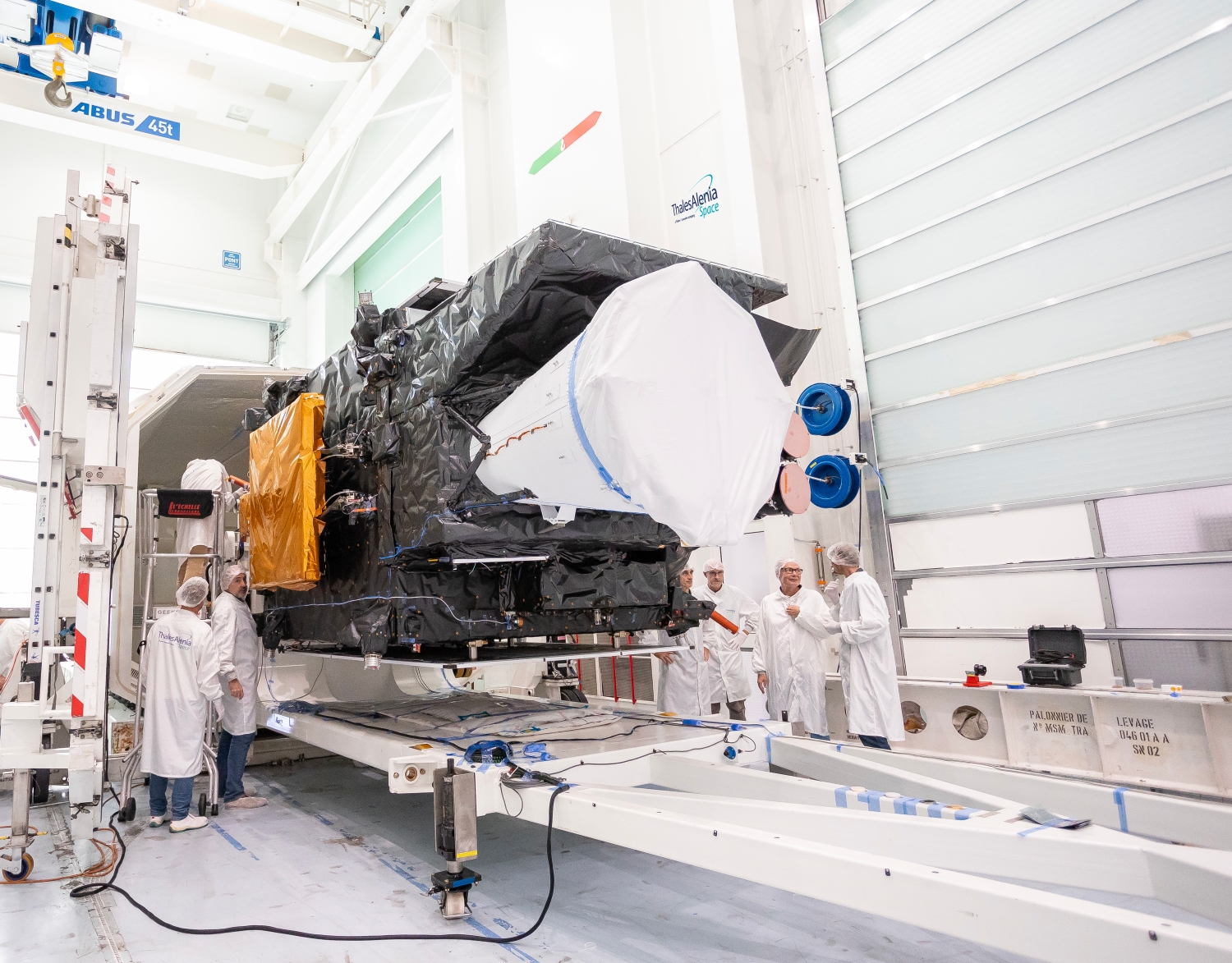
First MTG imaging satellite © Thales Alenia Space/Imag[IN]
With its day-night and all-weather radar, Sentinel-1 is keeping track in real time of landslides, earthquake zones, volcanic activity, sea ice, and polar ice sheets. The mission is also delivering precious data for monitoring deforestation and the use of water resources, and supporting first responders and search-and-rescue teams in the event of natural disasters.
But it is above all Sentinel-1’s automatic identification system (AIS) payload that makes it so valuable for maritime safety, by facilitating shipping traffic management, anticipating and avoiding collisions at sea, and keeping track of ships in critical areas. As prime contractor for the mission’s space segment, Thales Alenia Space is responsible for satellite design, development, integration and testing.
Sentinel-3: precisely recording the impact of global warming

Sentinel-3 © ESA
The Sentinel-3 mission is dedicated to surveying the world’s oceans and land surfaces. The satellites’ thermal and optical sensors are acquiring detailed data on surface temperature, ocean color, marine currents, and sea level, all vital for improving ocean and climate predictions and managing marine resources sustainably.
The Sentinel-3 mission comprises four satellites in Sun-synchronous orbit. The first two, Sentinel-3A and 3B, were launched in 2016 and 2018, and are operating in tandem to provide optimal global coverage.
As satellite prime contractor, Thales Alenia Space is responsible for the spacecraft bus and two of its main instruments: the imaging spectrometer and the synthetic aperture radar.
Sentinel-6: surveying sea level rise
Following in the footsteps of the TOPEX/Poseidon and Jason missions, Sentinel-6 is ensuring continuity of sea level rise measurements, a key indicator of climate change. It is also acquiring data on ocean topography and wave height, useful for anticipating coastal area risks and refining climate models. Our teams are proud to have built the satellite’s radar altimeter.
In “pole” position with CRISTAL and CIMR

CIMR © Thales Alenia Space
The CRISTAL and CIMR missions complete a cutting-edge fleet of satellites dedicated to monitoring the polar regions, key indicators of climate change.
CRISTAL focuses on measuring sea ice thickness and the height of ice sheets, using an advanced altimeter developed by Thales Alenia Space.
Meanwhile, the CIMR mission is gathering vital data on Arctic Ocean conditions, such as temperature, salinity, and ice coverage to deepen our understanding of climate dynamics in this sensitive and rapidly changing environment.
New and innovative projects are also coming on stream. One such is Ocean Venture, a project focused on current and future marine issues. Its mission is to protect biodiversity against the development of offshore wind farms and possible deep sea mining, to mitigate damage to ecosystems, and to pave the way for the exploration of oceans on other planetary bodies, like the one lying beneath the icy crust of Enceladus, Saturn’s mysterious moon.
Observing and protecting Earth
Thanks to our advanced technologies, we are not simply surveying the oceans; we are also able to anticipate extreme weather events.
Meteorology 3.0 with MTG

MTG - I1 © Mathieu Persan
With extreme weather events increasing in intensity, reliable and accurate forecasting is now more vital than ever before. To meet this challenge, Europe is deploying the Meteosat Third Generation (MTG) series of cutting-edge geostationary weather satellites. With Thales Alenia Space as lead contractor, the MTG program—composed of four imaging satellites (MTG-I) and two atmospheric sounding satellites (MTG-S)—is seeking to revolutionize modern meteorology by increasing the accuracy of weather forecasts. Severe storms are getting more frequent with climate change, endangering populations and ecosystems alike. Thanks to its more precise and timely observations, MTG will allow us to alert populations and emergency management agencies earlier, anticipating the impacts of storms and heatwaves.
Launched in 2022, MTG-I1 beamed back its first images of Earth in 2023, surpassing the performance of previous Meteosat generations. This satellite features the Flexible Combined Imager (FCI), a new-generation instrument designed to improve the accuracy of weather forecasts, from just a few minutes ahead out to several hours. This instrument scans the full Earth disc in 16 spectral bands every 10 minutes, against 15 minutes with the previous generation, and offers a fast imaging mode able to zoom in on Europe every 2½ minutes. The MTG-I satellites also have a Lightning Imager (LI), while the MTG-S satellites can map the atmosphere in 3D.
Built by OHB, the first atmospheric sounding satellite, MTG-S1, is set for launch this year. Together, the two MTG-S satellites will offer a detailed 3D map of the atmosphere, providing an unprecedented picture of weather systems. Once all six MTG satellites are in orbit, EUMETSAT (European Organisation for the Exploitation of Meteorological Satellites) will offer the most sophisticated weather forecasting services in the world. Thales Alenia Space’s teams are proud to have led the construction of three generations of Meteosat satellites since the launch of the very first flight model in 1977.
The IRIDE constellation serving Earth

IRIDE © Thales Alenia Space
Supported by Italy’s National Recovery and Resilience Plan (PNRR) and led by the European Space Agency (ESA) in partnership with the Italian space agency (ASI), IRIDE is a constellation of mainly radar but also optical microsatellites offering unrivaled prospects for monitoring Earth’s environment and managing its resources sustainably.
Employing various instruments and remote-sensing technologies, this constellation will cover a broad spectrum with radar—notably synthetic aperture radar (SAR), and optical sensors, at high and medium resolutions and in various frequency ranges, from panchromatic to multispectral, hyperspectral and infrared bands. Thales Alenia Space will build 12 SAR satellites and an optical satellite, based on the NIMBUS (New Italian Micro Bus) modular spacecraft bus designed with high-revisit, high-capacity constellations in mind.
In addition to providing services to the Italian government, IRIDE will also support civil protection services and other agencies in fighting hydrogeological instability and wildfires, protecting coastlines and monitoring critical infrastructures, and measuring air quality and weather conditions. The system will also provide data analytics for the development of commercial applications by startups, small and medium-sized enterprises and diverse sectors of industry.