In the Spotlight
Sentinel-3B ready for launch
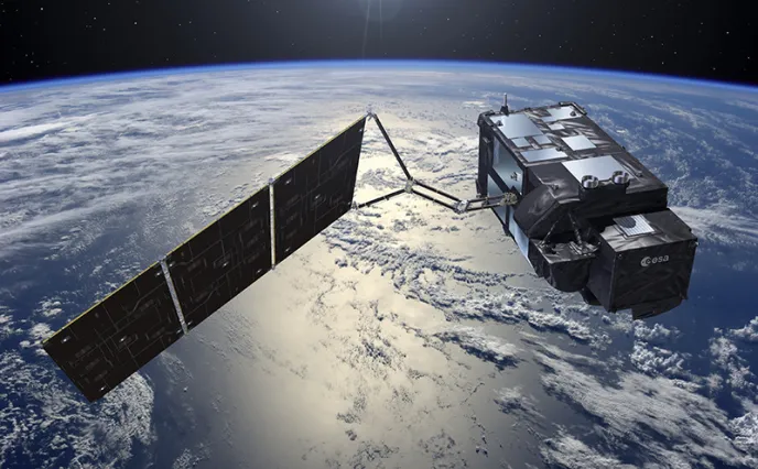
The European Space Agency’s latest Earth observation satellite, Sentinel-3B, will be orbited by a Rockot launcher from the Plesetsk Cosmodrome on April 25. Sentinel-3B has a two-pronged maritime and terrestrial mission, spanning oceanography, land hydrology and vegetation monitoring on land.
Taking a close look at our oceans
Oceans cover some 70% of our planet, which means they have a direct impact on both climate and weather. Our oceans harbor a plethora of essential resources that must be preserved, as well as providing multiple sea lanes for international trade.
For example, by measuring surface temperatures, we can meticulously monitor mysterious climate phenomena such as El Niño. Originating off the Pacific coast of South America as a warm seasonal coastal current, El Niño is characterized by abnormally high water temperatures. This in turn leads to significant atmospheric disturbances, displacing rain zones and causing considerable damage to the fishing industry. The data expected from Sentinel-3B could help characterize climate phenomena of this type, as well as all types of natural disasters, from hurricanes to tsunamis.

Sentinel-3B will also be extremely useful in monitoring maritime transport, for example by detecting icebergs, and measuring the height and movement of waves. This is vital data, enabling us to improve maritime safety.
Furthermore, sea and ocean color data will be analyzed to identify areas with algae and phytoplankton – information that will prove invaluable to the fishing industry.
Land Ho!

Services based on Sentinel-3B data will greatly benefit agriculture as well. Having accurate and up-to-date information is an ideal way to help farmers monitor any changes in their crops and land use. This data can also be used either globally or even locally, since we are seeing a real boom in small and medium-size businesses that are developing services based on data from Sentinel-3A (Sentinel-3B’s twin, operational in orbit since 2016). One of the examples cited regularly by ESA concerns a consortium of 25 truck farmers in the Netherlands, who are already using data generated by Sentinel-3A to optimize their expansion and monitor the “health” of their production.
In addition to global monitoring of oceans, the Sentinel-3 satellites also measure river height and water quality (to detect any source of pollution or bacteriological contamination). Once again, a number of SMEs have begun developing services and applications in this area, in particular to analyze areas that are difficult to reach any other way.
In addition to global monitoring of oceans, the Sentinel-3 satellites also measure river height and water quality (to detect any source of pollution or bacteriological contamination). Once again, a number of SMEs have begun developing services and applications in this area, in particular to analyze areas that are difficult to reach any other way.
The four instruments on Sentinel-3B

Like other members of the Sentinel-3 family, the 3B bird is a sophisticated spacecraft, with four different instruments cleverly laid out in a restricted space:
- Two optical instruments: OLCI (Ocean and Land Color Instrument) and SLSTR (Sea and Land Surface Temperature Radiometer).
- Two RF (radio-frequency) instruments: SRAL (Synthetic-aperture Radar ALtimeter), and MWR (Microwave Radiometer), which will provide measurements to determine the topography of oceans, ice, sea ice and water bodies on land.

Copernicus and the waltz of the Sentinels

The Sentinel spacecraft are developed on behalf of ESA within the scope of the European Union’s Copernicus program. They are a key to Europe’s environmental monitoring efforts. There are actually six Sentinel families, of satellites or instruments: Sentinel-1 is designed to provide continuity for the radar data collected by ERS and Envisat; Sentinel-2 and -3 are dedicated to monitoring land and oceans. The Sentinel-4 and -5 instruments are designed for meteorology and climatology missions. Sentinel-6 will provide operational continuity for Jason altimetry missions. Thales Alenia Space is prime contractor for the Sentinel-1 and -3 families (4 satellites each), is in charge of the image ground segment for Sentinel-2, and makes the imaging spectrometer carried by Sentinel-5P as well as the Poseidon-4 radar altimeter for the Jason-CS/Sentinel-6 mission.
Copyrights:
Artistic views 1, 3 &7: © ESA
Photos 2, 4 & 6: © Thales Alenia Space/Master Image Programmes
Photo 5: © Thales Alenia Space/Imag[IN]